Boundary Clearing FAQ
The Rural Boundary Clearing Code allows rural landowners to clear certain vegetation along the boundary of their landholding to reduce the potential for the spread of bush fires.
This Code was introduced to simplify and empower vegetation management for rural landholders and addresses the intent of Recommendation 28 of the NSW Bushfire Inquiry, which was commissioned following the devastating 2019/20 NSW bush fires which cost the lives of 26 people and destroyed 2,476 homes across NSW.
The Inquiry recommended:
28. That Government acknowledging that a strategic approach to planning for bush fire will take time, and in order to protect, prepare and build resilience into existing communities better, should immediately:
- review vegetation clearing policies to ensure that the processes are clear and easy to navigate for the community, and that they enable appropriate bush fire risk management by individual landowners without undue cost or complexity.
The ‘Rural Boundary Clearing Code for New South Wales (Rural Boundary Clearing Code)’ has been prepared by the Minister for Police and Emergency Services in consultation with (and the concurrence of) the:
- Minister for Energy and Environment,
- Minister for Planning and Public Spaces, and
- Minister for Agriculture / Minister for Western New South Wales,
in accordance with Section 100RA(5) of the Rural Fires Act 1997.
The objective of the Rural Boundary Code is to simplify vegetation management for owners or occupiers of land for the purpose of bush fire hazard mitigation by allowing them to clear vegetation on their property within 25 metres of their property boundary. This should be undertaken with consideration of environmental impacts.
This will assist landowners in meeting their duty under Section 63(2) of the Rural Fires Act 1997 to take any notified steps or any other practicable steps to prevent the occurrence of bush fires on, and to minimise the spread of bush fires on or from, their land.
The Rural Boundary Clearing Code will assist landowners to limit the spread of fire and extend the existing exempt clearing provisions in NSW to provide for clearing, as firebreaks, along property boundaries. The scheme is designed to facilitate bush fire hazard reduction works to limit fire spreading from or entering properties.
It is the responsibility of the owner (or occupier) of the land to maintain a copy of the Rural Boundary Clearing online tool search results from the day (or each day) that the clearing is undertaken. Landowners are required to provide evidence of the online tool search results in the circumstance that a relevant regulatory authority seeks such evidence.
The Rural Boundary Clearing Code is available for download at www.rfs.nsw.gov.au/boundaryclearingcode
The Code will apply to any holding within a rural zone within the Boundary Clearing Code Vegetation Map (derived from bush fire prone land 2015 Guide for Bush Fire Prone Land Mapping)
The Rural Boundary Clearing Code provides for vegetation clearing work within 25 metres of the boundary of a holding that is:
- within land zoned rural (except where a council has not opted in),
- within the Boundary Clearing Code Vegetation Map (i.e. mapped as bush fire prone);
- on their own property;
- but no clearing is allowed if the land is excluded by mapping or otherwise (refer to FAQs).
Be aware that the allowable clearing may apply to all of your holding boundary, only some of your boundary, or none of your boundary. The online tool highlights the location of where you can or can’t. The potential allowable clearing only applies to the boundary of your holding not the boundary of each individual Lot.
Rural Boundary Clearing
The Rural Boundary Clearing Code gives rural landholders an additional way of being better prepared for bush fires.
The Code allows people in a designated area to:
Clear vegetation (including trees) on their property within 25 metres of the boundary of their rural landholding, without seeking approval. There are some limitations on the application of the clearing provisions and further advice regarding these limitations can be found within the Rural Boundary Clearing Code, and the FAQs below.
You can find out if your property is in a Rural Boundary Clearing Area using our online tool.
The Rural Boundary Clearing scheme is supported by the Rural Boundary Clearing Code.
Examples of how the Rural Boundary Clearing Code may apply to your Holding
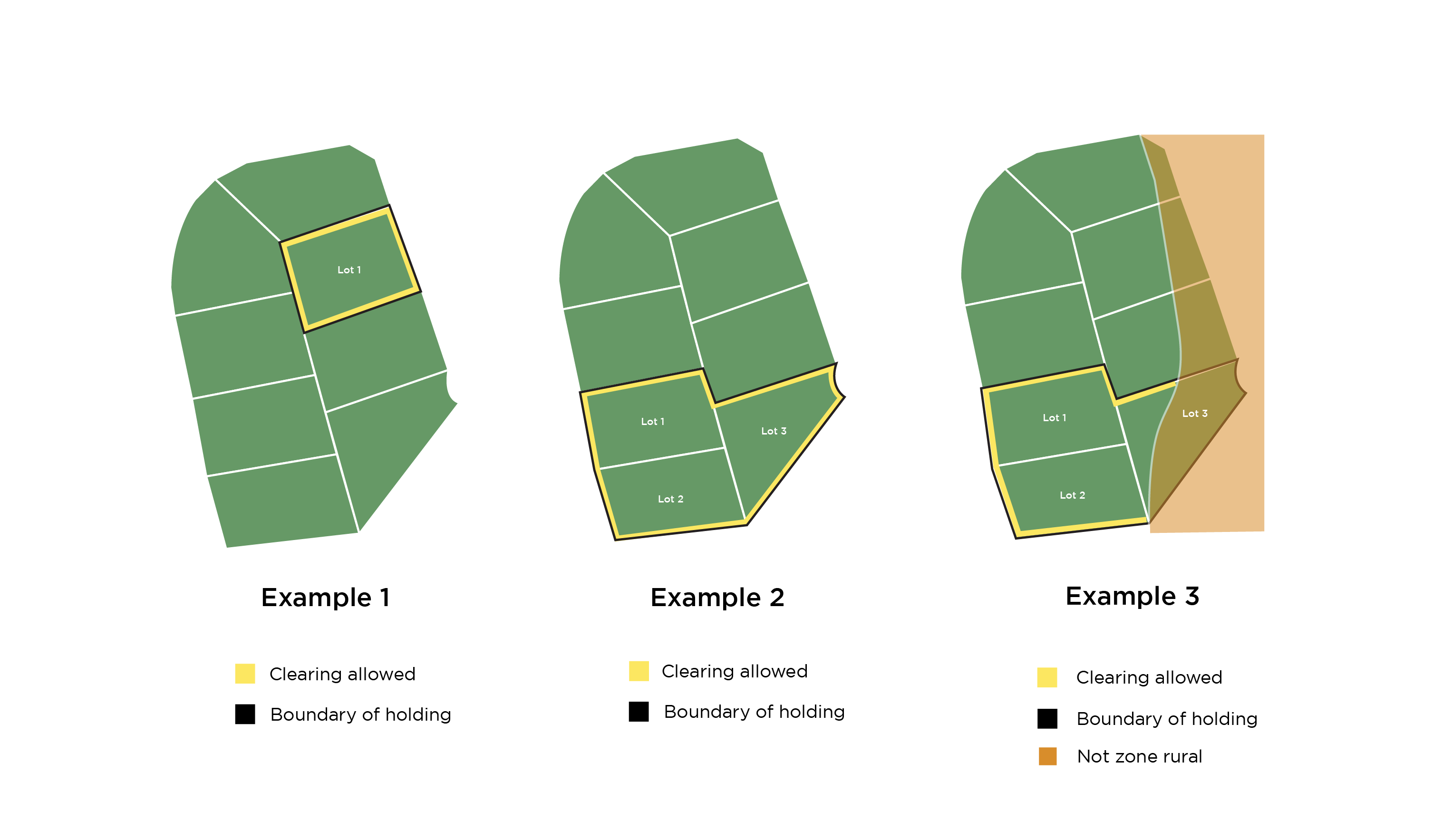
Example 1
Holding is a Single Lot and the boundary clearing applies to your Lot boundary as there are no exclusions.
Example 2
Holding consists of multiple Lots and the boundary clearing applies to the external boundary of the holding as there are no exclusions.
Example 3
Holding consists of multiple Lots and the boundary clearing applies to the external boundary of the holding except where that part of the holding boundary is mapped as non-rural.
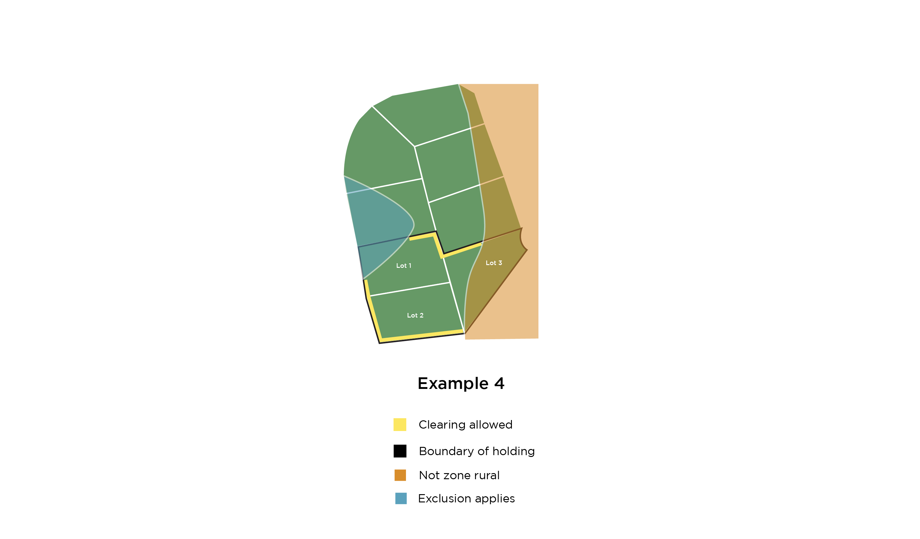
Example 4
Holding consists of multiple Lots and the boundary clearing applies to the external boundary of the holding except where that part of the holding boundary is mapped as:
- non-rural, or
- an exclusion.
Check the online tool on the day you are clearing
Check the online tool on the day you are clearing to re-confirm your eligibility to clear vegetation under the Rural Boundary Clearing Scheme. This is because the Rural Boundary Clearing area, the excluded matters or other rules may have changed. It is important to know that you must follow the eligibility rules in place at the time you clear any vegetation.
You may only clear your own land.
Prepare your home and families
The NSW RFS provides extensive information and resources to assist people interested in preparing their homes and families against the risk of bush fires. Try some of the useful links below for more information:
- Download a bush fire survival plan
- Download the Bush Fire and Your Home fact sheet
- Download the Prepare. Act. Survive fact sheet
- Visit our Farm Fire Safety page
- Download the Bush Fire Myths fact sheet
Current Opt In Status of Sydney Councils
The Rural Boundary Clearing Code does not apply to the following councils unless the Council has requested to opt in. Such requests must be made by the council in writing to the Commissioner of the NSW Rural Fire Service.
Council | Opted In | Not Opted In (advice received) | Not Opted In (no advice received) |
Blacktown City, | Applies | ||
Campbelltown City, | Applies | ||
Camden, | Applies | ||
Cumberland, | Applies | ||
Fairfield City, | Applies | ||
Georges River, | Applies | ||
Hawkesbury City, | Applies | ||
The Council of the Shire of Hornsby, | Applies | ||
The Council of the Municipality of Hunters Hill, | Applies | ||
Ku-ring-Gai, | Applies | ||
Lane Cove Municipal, | Applies | ||
Liverpool City, | Applies | ||
Northern Beaches, | Applies | ||
City of Parramatta, | Applies | ||
Penrith City, | Applies | ||
Sutherland Shire, and | Applies | ||
The Hills Shire. | Applies |
Relevant Government Authorities Responsible for the Exclusion Reasons
Please contact these authorities if you have enquiries regarding the mapping in the online tool.
Note:
DPIE – Department of Planning, Industry and Environment
DPIE (EES) – Department of Planning, Industry and Environment (Environment, Energy and Science)
Exclusion Reasons
| Relevant Authority | Website / Email | Phone |
Non-Rural Zone | DPIE (Planning) AND Councils | 1300 305 695 | |
Non-bush fire prone | NSW RFS | (02) 8741 5555 | |
Fire Scar | NSW RFS | (02) 8741 5555 | |
Biodiversity – Critically Endangered Ecological Communities | DPIE (EES) | 1300 361 967 | |
Koala Habitat | DPIE (Planning) | 1300 305 695 | |
Heritage (Local, State, World) | DPIE (Planning) | 1300 305 695 | |
Coastal Wetlands and Rainforest | DPIE (Planning) | 1300 305 695 | |
Coast and Estuaries | DPIE (EES) | 1300 361 967 | |
Aboriginal Places | Heritage NSW | (02) 9873 8500 | |
Scarred Trees | Heritage NSW | (02) 9873 8500 | |
Significant Vegetation | DPIE (Planning) | 1300 305 695 | |
Cumberland Plain | DPIE (Planning) | 1300 305 695 | |
Ramsar Wetlands | DPIE (EES) | 1300 361 967 | |
Riparian | DPIE (EES) | 1300 361 967 |
A series of frequently asked questions has been published to provide additional information and can be accessed below. Simply click on a question to expand the answer.
If you still have questions about the application of the Rural Boundary Clearing Code then email Rural.Boundary@rfs.nsw.gov.au and include your address, contact details, your question, and we can provide advice.
How can I get a copy of the Rural Boundary Clearing Code?
You can download the Rural Boundary Clearing Code here.
How do I obtain approval to clear under the Rural Boundary Clearing scheme?
You do not need an approval to clear under the Rural Boundary Clearing Code, but you MUST comply with the provisions of the Code before you clear your land. The online tool will help you determine if you can clear your boundary. You can face significant penalties if you do not comply with the Code
The Code does not over-ride Commonwealth laws.
How do I retain records?
You need to check the Rural Boundary Clearing online tool on the day you are clearing to confirm (or re-confirm) your eligibility to clear vegetation under the Rural Boundary Clearing Code. This is because the Rural Boundary Clearing area, the excluded matters or other rules may have changed. It is important to know that you must follow the eligibility and rules in place at the time you clear any vegetation.
You should retain a copy of your online tool search output for your records as evidence the Rural Boundary Clearing rules were applicable to your clearing on the day you undertook the clearing.
What does the Rural Boundary Clearing scheme allow me to do?
If the Rural Boundary Clearing area applies to all or part of your landholding, the scheme allows you to clear vegetation (without seeking approval) within 25 metres of the boundary of a holding that is:
- within land zoned rural (except where a council has not opted in),
- within the Boundary Clearing Code Vegetation Map (i.e. mapped as bush fire prone);
- on your own property;
- but no clearing is allowed if the land is excluded by mapping or otherwise.
Note: there may be restrictions that apply, such as if your property is on a slope, or there are items of Aboriginal or cultural significance in the area. Find out more below.
Where do I measure the 25 metres from?
The distance is from the boundary of your landholding on your side of the boundary only.
If your boundary lies within the middle of a river (for example) then you must measure the 25 metres from the middle of that river.
If you are uncertain of the exact location of your boundary then you should either engage a surveyor or otherwise assure yourself that you are not clearing land that you do not own. It is unlawful to clear land that is not yours.
Noting that you may not clear any excluded part of the boundary of your holding.
Who do the rules apply to?
The Rural Boundary Clearing Code only applies to holdings within a rural zone (unless your council has not opted in) that are within the Boundary Clearing Code Vegetation Map (derived from bush fire prone land 2015 Guide for Bush Fire Prone Land Mapping) and within 25 meters of the holding’s boundary with adjoining land.
Use the Rural Boundary Clearing online tool to determine if your landholding is eligible. Noting that you may not clear land that is excluded (whether mapped or otherwise – refer to relevant FAQ).
Clearing can only be done if you are the owner or you have the approval of the owner. Owner is defined in the Rural Boundary Clearing Code.
The Rural Boundary Clearing Code does not place a requirement on owners to clear trees or vegetation if they do not wish to take that action. It is a tool available to help improve protection against bush fires, if owners wish to take that action.
How can I find out if I can clear vegetation under the Rural Boundary Clearing scheme?
You can search for your parcel of land to see whether all or part or none of your landholding is in the Rural Boundary Clearing area.
If your landholding is made up of more than a single parcel of land (Lot) then you need to identify the boundary of your holding. You can do this visually using the online tool. Once you print your report you should use a pen or pencil to mark the boundary of your holding and then identify the parts of your holding boundary that you may clear.
The online tool will also let you know if there are any restrictions on the clearing that apply to your landholding. See FAQ below 'How do I know which exclusions apply to my land?'. This FAQ will also guide you on those exclusions that are not mapped.
How do I locate my land using the online tool?
Type in your chosen Lot/Section/Plan or address (in full) and then select your Lot/DP or address from the drop-down list.
Once selected the screen will ‘zoom’ to your selected property. If your property contains more than a single parcel of land (Lot) then you may need to ‘zoom’ out so that you view the boundary of your holding.
Enter your address including house/street number, road and suburb or town. Select your address from the drop down options provided OR select the LOT OR PARCEL tab, and enter your Lot, Section and Plan number.
Check the map has correctly located your landholding. If not click on the map screen and drag the map to your property, or zoom out to locate prior to zooming in again on the correct location.
Use the zoom function to create a view that encompasses your landholding. For larger landholding you may undertake additional searches to produce maps that display sufficient detail.
NB: If you hover your mouse over the Map/Satellite boxes then you will have the option to turn on the ‘Labels’ which will populate the map with road names.
What should I do if I cannot locate my land using the online tool?
If you search for your landholding and you see a pop-up error box that reads 'We cannot locate your address on the map' then you should consider the following:
The online tool works using Google, and Google may not recognise your address or Lot details. This may be because Google has your suburb or street identified differently to you. It may also be because your land has been relatively recently subdivided and Google has not updated the new Lots/addresses.
If you still cannot locate your property, enter and search on the name of the closest cross street, and select from the drop-down list and click and drag the map to your property.
Google will show your address/Lot you have selected on the map at a standard scale. In order to see whole of the boundary of your holding you may need to adjust the scale (by zooming in or out).
If you continue to have difficulty with the online tool you should consider downloading and using Google Chrome as your web browser.
What is a holding?
A holding includes a parcel of land or several parcels of land (whether held under the same title, different titles or different kinds of titles) that constitute or are worked as a single property and that are contiguous with one another or are separated from one another only by a road, river, creek or other watercourse;
What is a Rural Zone?
Rural zone means the following zones under the Standard Instrument (or a zone under another instrument that is equivalent to one of the following zones):
- RU1 Primary Production
- RU2 Rural Landscape
- RU3 Forestry
- RU4 Primary Production Small Lots
- RU5 Village
- RU6 Transition
- Or the equivalent in the Unincorporated Zone.
NB: Where a landholding has two or more zonings either partially or wholly affecting it, vegetation clearing under the Rural Boundary Clearing Code is considered to be authorised clearing only for that portion of the holding zoned RU.
How do I know which exclusions apply to my property?
The online tool identifies the majority of exclusions by maps provided to the NSW RFS by the relevant Government authority. In the event that a mapped layer held by the relevant authority is different to that on the NSW RFS online tool, it is the version on the online tool that applies to the Rural Boundary Clearing Code.
The types of vegetation that cannot be cleared are separated into three categories based on the availability and accuracy of maps: mapped exclusions that always apply, mapped exclusions that don’t apply if the mapping is inaccurate, and exclusions which are not mapped. Please see the two FAQs immediately below for more information.
What is excluded from being cleared (and mapped in the online tool)?
There are two types of exclusions that are mapped in the online tool – those where the maps clearly identify the excluded area, and those where the landowner may confirm with the relevant authority whether the exclusion actually applies to their land or not. Note that there are also exclusions which are not mapped – see the FAQ ‘Which exclusions do I need to identify as they are not mapped in the online tool?’.
1. The exclusion maps clearly identify the excluded area.
Parcels of the following vegetation are mapped in the Rural Boundary Clearing online tool and may not be cleared under the Rural Boundary Clearing Code. The onus is on the owner or occupier of the land to demonstrate that they did not clear any vegetation that constitutes any of the following types of vegetation:
- SEPP Coastal Management - Coastal Wetlands (not including the proximity area) as mapped and provided to the NSW RFS by the Department of Planning, Industry and Environment;
- Wetlands in the Sydney Regional Environmental Plan (Sydney Harbour Catchment) 2005 as mapped and provided to the NSW RFS by the Department of Planning, Industry and Environment;
- Wetlands in the Sydney Regional Environmental Plan 20 – Hawkesbury Nepean River (No 2 – 1997) as mapped and provided to the NSW RFS by the Department of Planning, Industry and Environment;
- SEPP Coastal Management – Littoral Rainforests (not including the proximity area) as mapped and provided to the NSW RFS by the Department of Planning, Industry and Environment,
- Core Koala habitat identified at Attachment ‘A’ of the Rural Boundary Code as mapped and provided to the NSW RFS by the Department of Planning, Industry and Environment;
- Ramsar Wetlands;
- vegetation within 100 metres of the coastline or estuaries of NSW;
- any vegetation on Lord Howe Island;
- Land mapped as Declared Area of Outstanding Biodiversity Value (as listed in Attachment A of the Rural Boundary Clearing Code – Vegetation Types) as mapped and provided to the NSW RFS by the Department of Planning, Industry and Environment;
- Critically Endangered Ecological Communities (as listed in Attachment A of the Rural Boundary Clearing Code – Vegetation Types) as mapped and provided to the NSW RFS by the Department of Planning, Industry and Environment;
- ‘Land avoided for strategic biodiversity’ and ‘strategic conservation area’ (as listed in Attachment A of the Rural Boundary Clearing Code – Vegetation Types), whether exhibited as part of the draft Cumberland Plain Conservation Plan (CPCP) or the approved CPCP, and as mapped and provided by the Department of Planning, Industry and Environment.
Other mapped exclusions (which may not be cleared) include:
Aboriginal Places and Aboriginal culturally modified trees (also known as ‘Aboriginal scarred trees’). Please see FAQ – 'What are my requirements to prevent damage or harm to Aboriginal heritage on my land?’.
Protected riparian land as mapped in the online tool may not be cleared. Please see FAQ – 'Can I clear vegetation in or adjacent to waterways and waterbodies?’.
2. The exclusion map does not apply if mapped incorrectly
Although parcels of the following vegetation are mapped in the online tool (and may not be cleared under the Rural Boundary Clearing Code) there may be inaccuracies with the mapping that may result in your land parcel being wrongfully identified. Land parcels that do not contain any of these legal protection measures (despite being mapped as one of those categories) are not excluded.
The onus is on the owner or occupier of the land to demonstrate that their land parcel does not contain the identified legal protection measure by contacting the relevant authority.
The relevant protected categories and contacts are:
- World Heritage (contact the Department of Planning, Industry and Environment),
- Vegetation of high environmental significance identified as part of the bio-certification of the Sydney Region Growth Centres (contact the Department of Planning, Industry and Environment),
- NSW State heritage (contact the Department of Planning, Industry and Environment), and
- Local heritage (contact your local council).
Which exclusions do I need to identify as they are not mapped in the online tool?
Mangroves and coastal saltmarsh are as described in NSW Department of Primary Industries Primefact 746 May 2008 – Mangroves, and Primefact 1256 March 2013 – Coastal saltmarsh prepared by NSW Fisheries and may not be cleared under the Rural Boundary Clearing Code.
Rivers and lakes (as defined in the Rural Boundary Clearing Code) need to be identified on your property as your clearing must not cause stream bank instability and any process that results in declining water quality for any lakes or rivers. For more information see FAQ 'Can I clear vegetation in or adjacent to waterways and waterbodies?’. Although some riparian areas (land adjacent to rivers and lakes) are mapped as exclusions, the above requirements apply to all rivers and lakes (as defined by the Rural Boundary Clearing Code).
Slopes of more than 18 degrees. You are responsible for determining the slope of the area you wish to clear and ensuring that trees are not removed on slopes of more than 18 degrees (unless certain conditions are met). For more information see FAQ 'What if the tree I want to clear is on a slope?’.
Aboriginal Heritage: Landowners who clear trees and vegetation under the Rural Boundary Clearing Code are not exempt from prosecution under the National Parks and Wildlife Act 1974 for harm to Aboriginal heritage. For more information see FAQ – 'What are my requirements to prevent damage or harm to Aboriginal heritage on my land?’.
Harm to animals: Landowners who clear trees and vegetation under the Rural Boundary Clearing Code are not exempt from prosecution under the Biodiversity Conservation Act 2016 for harm to a protected animal, or for deliberate cruelty to animals under thePrevention of Cruelty to Animals Act 1979. For more information refer to FAQ – 'Do I have a responsibility to avoid harm to wildlife?’.
What if my clearing is not allowable under the Rural Boundary Clearing scheme?
If you are seeking to clear vegetation and the Rural Boundary Clearing does not apply to any part or all of your landholding area you should contact your local Council or Local Land Services Office to discuss your options for legally clearing the vegetation.
I'm inside the Rural Boundary Clearing area but am excluded from the Rural Boundary Clearing Code, how can I clear a tree or other vegetation?
If all or part of your landholding is restricted by an exclusion (and you are seeking to clear that area) then you should contact your local Council or Local Land Services Office to discuss your options for legally clearing the vegetation.
You may also contact your local NSW RFS District Office if you are seeking advice regarding managing bush fire risk on your land.
Do I have to clear vegetation if I'm in an eligible Rural Boundary Clearing area?
No. The Rural Boundary Clearing Code allows you to clear, but not does require it.
You may contact your local NSW RFS District Office if you are seeking advice regarding managing bush fire risk on your land.
What if the vegetation is on a neighbouring block?
You may not clear any neighbouring land.
You can ask neighbours to clear if the vegetation on their land is within 25 metres of your boundary. However they may only clear under the Rural Boundary Clearing scheme if it applies to their land.
Your neighbours (public or private) are not required to clear simply because they may use the Rural Boundary Clearing scheme, or because you would like them to.
You may prune branches within 25 metres of your boundary where those branches are overhanging your land from a tree on your neighbour's land, however you will need to comply with a range of conditions. For more information refer to the Frequently Asked Question below – 'Are there any conditions when pruning trees?'
If a tree trunk (or trunks) occurs across two or more properties, the written consent of all landowners is required for removal of the tree.
Note: the responsibility for the felling and removal of any such tree is a matter for agreement between the affected landowners, and should be articulated in any written agreement.
Why doesn’t the Rural Boundary Clearing Code apply to my council area?
The Rural Boundary Clearing Code does not apply to the following councils unless the Council has requested to opt in. Such requests must be made by the council in writing to the Commissioner of the NSW Rural Fire Service.
- Blacktown City
- Campbelltown City
- Camden
- Cumberland
- Fairfield City
- Georges River
- Hawkesbury City
- The Council of the Shire of Hornsby
- The Council of the Municipality of Hunters Hill
- Ku-ring-Gai
- Lane Cove Municipal
- Liverpool City
- Northern Beaches
- City of Parramatta
- Penrith City
- Sutherland Shire and
- The Hills Shire.
I rent or lease my land. Can I clear vegetation?
Clearing can only be done if you are the landowner or you have the approval of the landowner. If you rent your land, you will need to obtain the approval from the landowner first. More information on the definition of the ‘owner’ of land is contained in the Rural Boundary Clearing Code.
It is recommended you keep written evidence of the approval.
Does the Rural Boundary Clearing Code apply to both native and introduced vegetation?
Yes the Rural Boundary Clearing Code applies to any vegetation whether a native or introduced species.
What are the temporary exemptions for a bush fire affected holding?
A holding affected by bush fire between 1 July 2019 and 31 March 2020, as mapped in the NSW Rural Fire Service fire scar map displayed on NSW RFS website, is exempt from section 6.2 – 1 of this Code, except for mapped areas of:
- New England Peppermint (Eucalyptus nova-anglica) Woodland on Basalts and Sediments in the New England Tableland Bioregion;
- Marsh Club-rush sedgeland in the Darling Riverina Plains Bioregion;
- Robertson Basalt Tall Open-forest in the Sydney Basin and South Eastern Highlands Bioregions (Wingecarribee);
- Shale Sandstone Transition Forest in the Sydney Basin Bioregion;
- Sydney Turpentine Ironbark Forest in the Sydney Basin Bioregion;
- Cumberland Plain Woodland in the Sydney Basin Bioregion;
- Ramsar wetlands;
- Coastal wetlands and littoral rainforest as mapped in the State Environment Planning Policy (Coastal Management) 2018;
- Core koala habitat that has been identified in a koala plan of management under the State Environment Planning Policy (Koala Habitat Protection) 2020 as listed in Attachment A.
This exemption ceases to be in effect on 25 November 2022.
How will I know whether my holding was affected by bush fire for the purpose of the Rural Boundary Clearing Code?
You may view whether your holding is identified as being affected by bush fire between 1 July 2019 and 31 March 2020 as mapped in the NSW Rural Fire Service fire scar map on the online tool.
Click on this option in the online tool: SELECT HERE IF YOU WISH TO KNOW WHY ALL OR PART OF YOUR LAND IS EXCLUDED FROM THE RURAL BOUNDARY CLEARING CODE.
How do I apply the temporary exemptions apply for bush fire affected holdings?
If your holding lies within the RFS fire scar map, then you should check on the online tool whether any part of the boundary of your holding is restricted. If there are no restrictions then you do not need to consider the application of the temporary exemptions.
If any part of the boundary of your holding is restricted, then using the online tool click on ‘SELECT HERE IF YOU WISH TO KNOW WHY ALL OR PART OF YOUR LAND IS EXCLUDED FROM THE RURAL BOUNDARY CLEARING PROVISIONS’ which will expose the range of reasons why all or part of your holding is restricted. Turn on each reason in sequence to find out which reason or reasons restrict you.
If the reason is one of the following:
- Biodiversity – Critically Endangered Ecological Communities (some of these are temporarily exempted for holdings within the NSW RFS fire scar map, and some are not exempted). See previous FAQ for list of Critically Endangered Ecological Communities that are not exempted.
- Coastal Wetlands and Rainforest – Wetlands under the Hawkesbury Nepean REP and Sydney Harbour REP are temporarily exempted for holdings within the RFS fire scar map.
- Coast and Estuaries – land within 100 metres of the mapped Coast and Estuaries is temporarily exempted for holdings within the RFS fire scar map.
then please contact the RFS via email (Rural.Boundary@rfs.nsw.gov.au) with your enquiry seeking the RFS to provide you with a report.
Can I burn vegetation under the Rural Boundary Clearing scheme?
The Rural Boundary Clearing Code does not prevent you undertaking burning. However, you need to comply with a range of requirements including managing smoke.
Refer to the NSW RFS publication 'Before You Light That Fire' or contact your local NSW RFS District if you are seeking further information on burning and the types of approvals that may be required.
Nothing in the Code operates to exempt a person from their legal obligation to comply with:
- fire permit requirements under section 87 or section 88 of the Rural Fires Act 1997,
- notification requirements under section 86 of the Rural Fires Act 1997, and clause 33 of the Rural Fires Regulation 2013,
- Total Fire Ban declarations by the NSW RFS under section 99 of the Rural Fires Act 1997, or
- No Burn Notices declared by the Environment Protection Authority under section 133 of the Protection of the Environment Operations Act 1997,
- any requirements relating to road (or rail) safety and traffic management.
Are there any conditions when pruning trees?
You can prune any vegetation within 25 metres of your landholding boundary. However, pruning of trees must be in accordance with AS 4373-2007 Pruning of amenity trees. AS 4373-2007 is an Australian Standard for tree pruning that provides for trees to remain safe and healthy after branches are pruned. A copy of the Standard can be purchased from Standards Australia through their website www.standards.org.au.
If you plan to prune branches from a neighbour's tree that overhangs your land, you will need to determine whether pruning of the branches on their side is also required in order to balance the tree and meet the Australian Standard. If this is the case, then you will need their consent to prune the tree on their side. They must also comply with the Rural Boundary Clearing Code or have other lawful authority for the pruning on their land. You will need to do this before you commence any pruning of the tree.
In addition, if your land is on a slope of more than 18 degrees, pruning can only be done if at least 75% of the canopy is retained, except if undertaken in accordance with a Geotechnical Engineer Assessment Report prepared for that purpose.
Should I seek the services of a professional when pruning or removing a tree?
It is your responsibility to ensure tree removal and pruning is undertaken safely. You should always use reputable and professional tree services.
You should consider hiring only trained and qualified tree removal services. There are professional associations such as Tree Contractors Association Australia, the National Arborist Association of Australia, Arboriculture Australia, and the Institute of Foresters of Australia that can provide advice. Most Councils will also have information on recommended qualifications for arborists. Be aware that membership of an association does not always guarantee qualifications.
Tree removal does not require a trade licence in Australia. You should assure yourself that operators are appropriately qualified for the work being undertaken. TAFE NSW delivers training ranging from a Statement of Attainment, Certificate II, III and IV to Diploma level (also known as AQF levels 1-5. Be aware that untrained people may claim to be qualified. Therefore you should sight evidence of their qualifications.
You should check that any quotes from contractors include reference to meeting the NSW WorkCover Code of Practice for the Amenity Tree Industry. This provides a minimum set of standards for work place safety.
You should check that the service provider you use has current and appropriate insurances such as workers compensation, and personal and public liability insurance. You can also contact the insurance company to check that the policy is current and covers the type of work being undertaken. Your home insurance policy is unlikely to cover tree works. Tree removal services should also be licensed as a business and have an Australian Business Number (ABN).
Can I clear vegetation contrary to Tree Preservation Orders, the SEPP (Vegetation in Non-Rural Areas) 2017 or the Local Land Services Act 2013?
Yes. You may clear trees that would otherwise be protected by a Tree Preservation Order, the SEPP (Vegetation in Non-Rural Areas) 2017 or the Local Land Services Act 2013, if you clear in accordance with the Rural Boundary Clearing Code. You are not required to advise your local Council or Local Land Services if you are operating in accordance with rules.
Can I clear vegetation contrary to my Development Consent conditions?
No. You may not clear trees or other vegetation under the Rural Boundary Clearing Code contrary to a condition of development consent or approval under the Environmental Planning and Assessment Act 1979 that identifies and requires the retention and management of vegetation for conservation purposes. For example, if your Development Consent requires you to retain specified trees then you may not clear them. Contact your local council for a copy of your Development Consent conditions.
Can I clear vegetation contrary to an instrument under Section 88B of the Conveyancing Act 1919?
No. You may not clear trees or other vegetation under the Rural Boundary Clearing Code contrary to an instrument under Section 88B of the Conveyancing Act 1919 that identifies and requires the retention and management of vegetation for conservation purposes
Can I clear vegetation contrary to Land and Environment Court Orders or other Orders?
No. You may not clear trees or other vegetation under the Rural Boundary Clearing Code contrary to any applicable Land and Environment Court Order; or any other Court Order under the Criminal Appeal Act 1912, District Court Act 1973, Land and Environment Court Act 1979, Local Court Act 2007, Supreme Court Act 1970, or any order by a Court constituted under any of those Acts.
Can I clear vegetation contrary to Stop Work Orders, Interim Protection Orders or Remediation Directions?
No. You may not clear trees or other vegetation under the Rural Boundary Clearing Code contrary to any Stop Work Order, Interim Protection Order or Remediation Direction as per below:
- a Stop Work Order, Interim Protection Order or Remediation Direction under Part 6A of the National Parks and Wildlife Act 1974.
- a Stop Work Order under section 37 or Directions for Remedial Work under Section 38 of the Native Vegetation Act 2003, noting that stop work orders under the Native Vegetation Act continue under clause 54(2) of the Biodiversity Conservation (Savings and Transitional) Regulation 2017.
- a stop work order, interim protection order, remediation order, Biodiversity offsets enforcement order or direction relating to protected animals and threatened species of animals issued under Part 11 of the Biodiversity Conservation Act.
In addition, you may not clear land subject to a conservation measure pursuant to an Order for Biodiversity Certification.
What if there's a land management agreement (or set aside or conservation measure) covering my property?
Clearing under this Rural Boundary Clearing Code cannot be inconsistent with any of the following land management agreements:
- a conservation agreement entered into under Division 3 of Part 5 of the Biodiversity Conservation Act (this includes agreements entered under previous acts that are now taken to be conservation agreements under the Biodiversity Conservation Act)
- a Trust Agreement entered into under Part 3 of the Nature Conservation Trust Act 2001;
- a property management plan approved by the Director-General of the NSW National Parks and Wildlife Service under Section 113B of the Threatened Species Conservation Act 1995; or
- a Property Vegetation Plan agreement entered into under Part 4 of the Native VegetationAct 2003 and saved under clause 60 of the Biodiversity Conservation (Savings and Transitional Regulation 2017);
- a Biodiversity Stewardship Agreement entered into under Division 2 Part 5 of the Biodiversity Conservation Act (this includes agreements entered into under previous acts that are taken to be biodiversity stewarded agreements under the BC Act)
- An area that is set aside described under section 60ZC of the Local Land Services Act and registered on the public register.
- land subject to a conservation measure pursuant to an Order for Biodiversity Certification.
Do I need to consider impacts on koalas?
You may not clear trees or other vegetation under the Rural Boundary Clearing Code if your land has been identified by the online tool as containing core Koala habitat as mapped in the following Koala Plans of Management:
- Ballina Shire Council Comprehensive Koala Plan of Management;
- Bellingen Shire Council Comprehensive Koala Plan of Management;
- Coffs Harbour City Council Comprehensive Koala Plan of Management;
- Kempsey Shire Council Comprehensive Koala Plan of Management;
- Port Stephens Council Comprehensive Koala Plan of Management;
- Lismore City Council Comprehensive Koala Plan of Management;
- Campbelltown City Council Comprehensive Koala Plan of Management.
The Rural Boundary Clearing Code does not require you to consider any other Koala occupied areas that would otherwise be protected under NSW laws. However, please refer to the FAQ – Do I have a responsibility to avoid harm to wildlife?. This FAQ provides important guidance on your obligations regarding avoiding harm to wildlife.
In addition, you need to be aware that clearing in accordance with the Rural Boundary Clearing Code does not provide you with an approval under the Commonwealth Environment Protection and Biodiversity Conservation Act 1999 (EPBC Act). State laws cannot override Commonwealth laws. As such, the NSW RFS online tool does not provide advice on these matters.
See the Commonwealth Department of Environment's Fact Sheet on Bushfire Management and National Environment Law for further information.
You should contact the Commonwealth Department of Environment if you are seeking advice on the EPBC Act.
Do I need to consider impacts on threatened biodiversity?
You may not clear trees or other vegetation under the Rural Boundary Clearing Code if your land has been identified by the online tool as containing critical habitat, or one of the listed critically endangered ecological communities listed below.
- Agnes Bank Woodland in the Sydney Basin Bioregion;
- Artesian springs ecological community in the Great Artesian Basin;
- Blue Gum High Forest in the Sydney Basin Bioregion (EPBC);
- Cumberland Plain Woodland in the Sydney Basin Bioregion (EPBC);
- Hunter Valley Weeping Myall Woodland in the Sydney Basin Bioregion;
- Mallee and Mallee-Broombrush dominated woodland and shrubland, lacking Triodia, in the NSW South Western Slopes Bioregion;
- Marsh Club-rush sedgeland in the Darling Riverina Plains Bioregion;
- New England Peppermint (Eucalyptus nova-anglica) Woodland on Basalts and Sediments in the New England Tablelands Bioregion;
- Porcupine Grass – Red Mallee – Gum Coolabah hummock grassland/low sparse woodland in the Brocken Hill Complex Bioregion;
- Robertson Basalt Tall Open-forest in the Sydney Basin and South Eastern Highlands Bioregions (Wingecarribee);
- Shale Sandstone Transition Forest in the Sydney Basin Bioregion (EPBC)
- Sun Valley Cabbage Gum Forest in the Sydney Basin Bioregion;
- Sydney Turpentine Ironbark Forest in the Sydney Basin Bioregion;
Note that although there are 4 Critical Habitats currently listed, 3 are on NPWS Reserve, and 1 at North Head Sydney, none of which fall within rural zoned land.
The Rural Boundary Clearing Code does not require you to consider any other threatened species, populations or ecological communities that would otherwise be protected under NSW laws. However, please refer to the FAQ – Do I have a responsibility to avoid harm to wildlife?. This FAQ provides important guidance on your obligations regarding avoiding harm to wildlife.
In addition, you need to be aware that clearing in accordance with the Rural Boundary Clearing Code does not provide you with an approval under the Commonwealth Environment Protection and Biodiversity Conservation Act 1999 (EPBC Act). State laws cannot override Commonwealth laws. As such, the NSW RFS online tool does not provide advice on these matters.
See the Commonwealth Department of Environment's Fact Sheet on Bushfire Management and National Environment Law for further information.
You should contact the Commonwealth Department of Environment if you are seeking advice on the EPBC Act.
Are there any restrictions on clearing methods?
Yes. Methods of clearing that are not allowable under this Code include the use of chains (such as those used between two separate machines).
Please refer to the FAQ 'What are the requirements for managing soil erosion and landslip?’ and 'Who is responsible for soil erosion and landslip?’.
Please refer to the FAQ 'Can I Burn?’ for information regarding burning.
What are the requirements for managing soil erosion and landslip?
To manage soil erosion and landslip risks:
- The clearing of native vegetation must be undertaken in a manner that minimises the risk of soil erosion and landslip, and
- The landscape profile may not be altered.
In addition, tree removal is not permitted on slopes greater than 18 degrees except in accordance with conditions identified in a geotechnical engineer assessment report undertaken for that purpose.
Pruning of trees is only permitted on slopes greater than 18 degrees if at least 75 per cent of the original canopy cover is retained, except in accordance with conditions identified in a geotechnical engineer assessment report undertaken for that purpose
These conditions have been put in place to assist landowners in the management of vegetation but operating in accordance with these conditions does not absolve the landowners from their responsibility for landslip and erosion issues.
Who is responsible for soil erosion and landslip?
Landowners have a duty of care in the appropriate management of land degradation, including soil erosion, landslip risks (whether soil or rock fall), rising water tables or increase in salinity when clearing trees and vegetation under the Rural Boundary Clearing Code. Landowners who clear trees and vegetation under the Rural Boundary Clearing Code are not exempt from liability. For example, action may be pursued by a party that suffers as a result of a landslip due to actions taken on your land.
It is the responsibility of landowners to seek expert advice in relation to these matters.
The conditions in the Rural Boundary Clearing Code have been put in place to assist landowners in the management of vegetation, however, operating in accordance with the Rural Boundary Clearing Code including these conditions does not absolve the landowner from their responsibility for landslip and erosion issues.
What if the tree I want to clear is on a slope?
Some land may be susceptible to erosion or landslip. You cannot clear trees on slopes greater than 18 degrees on your land except in accordance with conditions identified in a Geotechnical Engineer Assessment Report.
In addition, if your land is on a slope of more than 18 degrees, pruning can only be done if at least 75% of the canopy is retained, except if there are conditions identified in a Geotechnical Engineer Assessment Report.
If you are unsure as to whether the tree you want to clear is located on a slope of more than 18 degrees you should seek professional advice i.e. from a surveyor or other appropriately qualified professional.
Can I clear vegetation in or adjacent to waterways and waterbodies (Riparian areas)?
Any areas mapped as protected riparian land in the online tool are excluded from the Rural Boundary Clearing Code.
In addition, the clearing must not cause stream bank instability and any process that results in declining water quality for any lakes or rivers. This applies to any ‘lake’ or ‘river’ as defined below, noting that for example a ‘river’ includes creeks, streams and the like.
- ‘lake’ includes:a lake, a wetland, a lagoon, a saltmarsh and any collection of still water, whether perennial or intermittent and whether natural or a natural body of water artificially modified, and whether or not it also forms part of a river or estuary.
- ‘river’ includes:any watercourse, whether perennial or intermittent and whether comprising a natural channel or a natural channel artificially modified, and any tributary, branch or other watercourse into or from which a watercourse referred to in paragraph (a) flows, and whether or not it also forms part of a lake or estuary.
You may not use machinery to clear vegetation within ‘rivers’ including creeks, streams and the like, nor within ‘lakes’. If machinery is used to traverse water channels then any damage to the stream bank must be restored. It is not appropriate to use machinery to traverse wetlands and the like due to the damage that is caused.
What are my requirements to prevent damage or harm to Aboriginal heritage on my land?
There are specific requirements regarding Aboriginal Places and Aboriginal ‘scarred trees’. There are also broader responsibilities to prevent damaging Aboriginal heritage (known or unknown) and any such damage or harm is not exempt from prosecution under the Rural Boundary Clearing Code. More detail below.
The online tool will identify whether there may be an Aboriginal Place or an Aboriginal culturally modified tree (scarred tree) on your land.
- Aboriginal Place: No clearing is allowed under the Rural Boundary Clearing Code if your land parcel has been identified by the online tool as being wholly or partially within areas mapped in the online tool as containing an Aboriginal Place.
- Aboriginal ‘scarred tree’: Landowners who are informed by the online tool that their land parcel may contain an Aboriginal culturally modified tree (scarred tree) are required to determine if the tree/s they wish to clear meet the criteria of an Aboriginal scarred tree as described in the Office of Environment and Heritage’s field manual for Aboriginal scarred trees in New South Wales. An Aboriginal scarred tree may not be cleared.
Landowners have a general duty of care to avoid harm to Aboriginal heritage when clearing vegetation in accordance with the Rural Boundary Clearing Code. It is important that landowners are aware that use of machinery (particularly heavy plant) to undertake clearing of trees and vegetation under the Rural Boundary Clearing Code can result in harm to Aboriginal heritage.
Landowners who clear trees and vegetation under the Rural Boundary Clearing Code are not exempt from prosecution under the National Parks and Wildlife Act 1974 for harm to Aboriginal heritage. Operating in accordance with the Rural Boundary Clearing Code does not absolve the landowners from their responsibility for avoiding harm to Aboriginal heritage. Note: ‘Aboriginal heritage is as defined in the National Parks and Wildlife Act1974. Landowners may avail themselves of relevant ‘defence’ provisions under the National Parks and Wildlife Act1974.
The protection of Aboriginal cultural heritage in NSW is managed by Heritage NSW. Aboriginal objects and places are protected under the National Parks and Wildlife Act 1974 (NPW Act).
Please contact Heritage NSW:
- https://www.heritage.nsw.gov.au/about-our-heritage/aboriginal-cultural-heritage-services/
- heritagemailbox@environment.nsw.gov.au
- (02) 9873 8500
What are my requirements to prevent damage to other heritage values on my land?
No clearing may be undertaken of vegetation that is protected by the relevant heritage listing (as mapped in the online tool). The landowner must consult with the authority responsible for the heritage listing to determine whether any or all of the proposed vegetation to be cleared is protected by the heritage listing.
However, land parcels that do not contain any of the legal protection measures below (despite being mapped as one of those categories) are not excluded from the Rural Boundary Clearing Code. This situation may occur due to inaccuracies with the mapping that may result in your land parcel being wrongfully identified. The onus is on the owner of land to demonstrate that their land parcel does not contain the identified legal protection measure.
Heritage listings include: Local Heritage, NSW State Heritage, and World Heritage.
Note: For example:
- if a parcel of land is identified as being local heritage but is not local heritage, then clearing is not excluded for that reason under the Rural Boundary Clearing Code; or
- if a land parcel is affected by a local heritage listing then clearing restrictions under the Rural Boundary Clearing Code apply to the vegetation affected.
Contact your local council for enquiries regarding Local Heritage.
Contact the Department of Planning, Industry and Environment (DPIE) for enquiries regarding State or World Heritage.
Do I have a responsibility to avoid harm to wildlife?
Yes. Landowners have a duty of care to avoid cruelty and harm to native, introduced or domestic animals when clearing trees and vegetation in accordance with the Rural Boundary Clearing Code. It is important that landowners are aware that clearing of trees and vegetation under the Rural Boundary Clearing Scheme can result in harm to native animals and loss of their natural habitat.
Accidental/incidental injury to wildlife is not a focus of compliance enforcement, consistent with the NSW Office of the Director of Public Prosecution’s guidelines. However, deliberate cruelty to animals may be subject to prosecution under the Prevention of Cruelty to Animals Act 1979.
You should take care to minimise your potential for harming wildlife such as having tree hollows checked and looking for active bird nests and tree dwelling animals such as koalas and possums.
If you witness any displaced, orphaned or injured wildlife you should contact the Department of Planning, Industry and Environment, or licensed fauna rehabilitation group for assistance. Visit the Department of Planning, Industry and Environment for further advice and the full list of licensed providers, such as the WIRES Wildlife Rescue group.
Only people authorised under a Department of Planning, Industry and Environment wildlife licence may take a native animal into care. Rehabilitating a native animal without an authority is illegal and can lead to prosecution. You are not allowed to keep rescued native animals as pets.
Landowners who clear trees and vegetation under the Rural Boundary Clearing Scheme are not exempt from prosecution under the National Parks and Wildlife Act 1974 for harm to protected fauna, or for deliberate cruelty to animals under the Prevention of Cruelty to Animals Act 1979. Operating in accordance with the Rural Boundary Clearing Code does not absolve the landowner from their responsibility for avoiding harm to protected fauna or deliberate cruelty to animals. Note: ‘protected fauna’ is as defined in the National Parks and Wildlife Act 1974.
Contact the Department of Planning, Industry and Environment for more information.
What If I want to (or I have been issued a notice from my energy network provider) manage trees around powerlines?
The Electricity Supply Act 1995 requires landowners to keep trees on their property a safe distance from powerlines all year round. Your network provider may notify you in writing of trees and branches that are too close to powerlines.
You should contact your network provider for any questions including the safety requirements. Working near powerlines is dangerous.
Although the Rural Boundary Clearing Code does not prevent clearing around powerlines nor does it specifically provide for clearing trees or vegetation around powerlines. Your network provider can advise you regarding your environmental approval options under the Electricity Supply Act 1995, and the appropriate approach.
Network providers include Ausgrid, Essential Energy, and Endeavour Energy.
What if my question isn't listed here?
Email Rural.Boundary@rfs.nsw.gov.au your address, contact details, your question and we can provide advice.

