Bush fire risk in the Snowy Valleys
Fire agencies, land managers and other stakeholders have been working to identify ways of reducing the impact of fires on our area – protecting lives, homes, businesses, agriculture, the environment and other assets that are important to the Snowy Valleys.
The local Bush Fire Management Committee has developed a Bush Fire Risk Management Plan, which identifies the risks and the plans to protect them.
The plan identifies the risk to communities and the assets we all value. Using feedback from fire agencies, land managers and other stakeholders, the plan identifies ways of reducing the impact of fires across our area.
By planning together, we will help shape the Bush Fire Risk Management Plan for our area for the next five years.
How the Snowy Valleys Bush Fire Risk Management Committee have assessed the risk
Fire is a part of living in the Snowy Valleys. It has been a part of this landscape for millions of years.
As our population and region changes, the risk of fires impacting on our community has changed.
To understand the bush fire risk in the Snowy Valleys, and help inform the best ways of managing and reducing the risk, we’ve looked at what’s important to local communities – including where people live, as well as environmental, economic and cultural assets.
We look at the assets across the landscape, and using computer modelling, we have tested scenarios for possible fire conditions to understand the impact on the community.
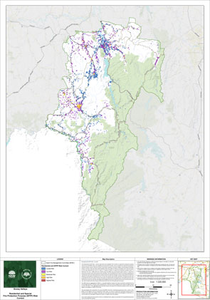
| Residential: The residential risk map shows the modelled risk to homes and properties from bush fires. Each coloured square on the map represents the risk to a home or a group of homes. The map displays the comparative risk across the local Bush Fire Management Committee area. If your home is in the lowest risk category it can still be damaged in a bush fire, it is just less likely to be damaged compared to other areas. |
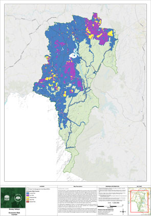 | Economic: The economic risk map shows the modelled risk to economic assets from bush fires. The risk is calculated based on the economic loss of the modelled damage assessment and how long it is expected that the asset will return to the pre-fire condition. These are important considerations because if they are destroyed during a fire, they can have long lasting impacts on employment and population in the area. |
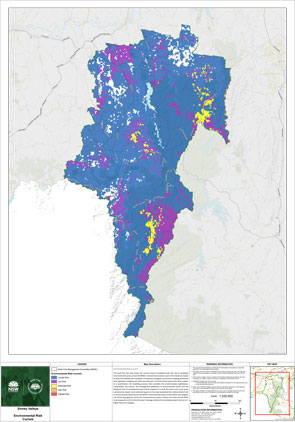 | Environmental: This map shows the environmental assets that have been modelled as being at highest risk from bush fire in the area. This includes areas at risk because they contain threatened species vulnerable to fire, vegetation types sensitive to fire e.g. rainforests or land managed for conservation or environmental outcomes that does not include fire. |
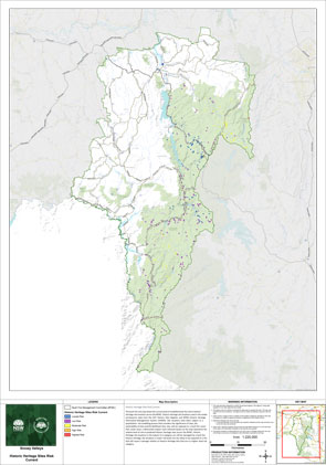
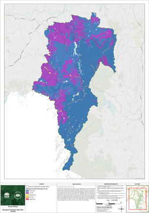 | Cultural Predicted Aboriginal Assets: This map shows the predicted Aboriginal cultural assets that have been modelled as being at the highest risk from bush fire in the area. |
 | Historic Heritage Sites: This map shows the modelled risk to historic heritage assets from bush fires. The risk is based on the significance of sites, the vulnerability of sites and the likelihood that sites will be exposed to a fire that will cause damage. |
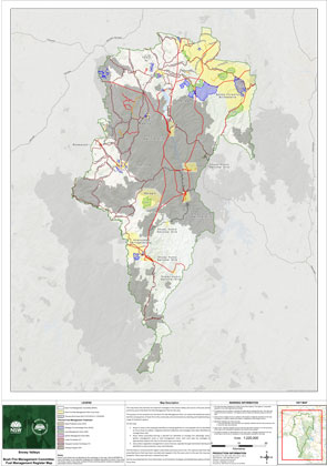 | Fuel Management Register and Focus Areas: This map shows the Fuel Management Register – a list of hazard reduction activities identified as strategic treatments in the risk plan. The Fuel Management treatments include prescribed burns, BFMC managed Asset Protection Zones and the development or maintenance of Fire Breaks. This map also displays the areas identified by the Bush Fire Management Committee as Focus Areas. |
Managing the risk in the Snowy Valleys
We have considered the risk to people and assets across the area to determine the most appropriate and effective way of managing that risk.
Some areas of the Snowy Valleys were impacted by the 2019/20 bush fire season, and these areas may have a reduced potential for fires spreading until vegetation fully recovers.
There are some measures which apply broadly – such as vegetation management, development controls, bush fire education, and fire suppression activities. These activities reduce the bush fire risk to assets and communities throughout the area.
Where an unacceptable risk exists for a particular area or assets, additional targeted treatment strategies are planned during the next five-year period. These treatment options include:
- Fuel management – the reduction or modification of bush fire fuel with the intent of slowing the spread of bush fire and aiding firefighting operations. This may be identified as;
- Asset protection zones – these are typically close to homes, and provide a separation from the bushland to reduce the impact of fires, and give firefighters a safe place to work if protecting homes in a fire;
- Ignition management zones – areas in the landscape maintained at a reduced fuel level to minimise the propagation of ignitions and limit the rapid escalation of fires;
- Strategic fire advantage zones – these are areas across the broad landscape which, when treated, can help slow the spread of a fire across the landscape;
- Land management zones – areas managed to maintain and enhance the natural and cultural values of the landscape and reduce the likelihood of bush fire spread through the use of mosaic fire regimes;
- Transport corridor fire breaks – areas along roadsides and rail corridors in which bush fire fuel is reduced to lower ignition potential and to provide areas from which fire can be suppressed;
- Other fire breaks – linear areas in which fuel is managed to provide areas from which a fire can be suppressed.
- Ignition prevention – activities to prevent or reduce bush fire ignitions whether they be accidental or deliberate. This includes community preparedness programs, fuel management and specific actions in the Ignition Prevention Plan.
- Community preparedness – activities such as working with residents to improve their level of planning and preparation for a fire, to increase the survivability of their home and families in the event of a fire.
- Response – specific response requirements for a particular area or value in addition to standard procedures. This may include specific actions in the BFMC Plan of Operations or Fire Access and Fire Trail plan.
Snowy Valleys BFMC is made up of a range of stakeholders from the area including emergency services, land management agencies, local government and local Aboriginal land services, and local community groups. This ensures key community stakeholders have a say on bush fire management activities for the benefit of their communities.
Snowy Valleys BFMC is made up of the following representatives:
- NSW Rural Fire Service
- NSW Department of Planning, Housing and Infrastructure (Crown Lands)
- Essential Energy
- Transgrid
- Snowy Hydro
- NSW Farmers' Association
- Fire and Rescue NSW
- NSW Forestry Corporation
- Snowy Valleys Council
- Bega, Brungle/Tumut, Eden, Merrimans and Wagonga Local Aboriginal Land Councils
- NSW National Parks and Wildlife Service
- NSW Police Force
- Transport for NSW
- Local Land Services
- Nature Conservation Council of NSW
- Southern Cross Forests
- Country Fire Authority Victoria
- ACT Rural Fire Service
- Tumbarumba Vignerons Association (observer)
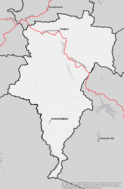
The Snowy Valleys Bush Fire Management Committee (BFMC) area spans 896,184 hectares (ha). The area covers the Local Government Area (LGA) of Snowy Valley Regional Council and features National Parks covering an area of 410,042ha and State Forests covering an area of 153,888ha. Also of interest is large tracts of private pine plantations as well as rich farming, grazing and horticultural land.
The Snowy Valleys area has approximately 75% bushland and 23% grassland with the balance being the built environment or water bodies. A bush or grass fire can happen at any time of the year, however the risk is higher during the warmer months of December to March, when bush, grass or scrub is at its driest.
-
 At the last census there are 6,481 residential dwellings in the Snowy Valleys BFMC area with an approximate population of 14,891.
 -
 There are 1,632 businesses in the area (ABS, 2021). The top three industries include Agriculture, Forestry and Fishing, Rental, Hiring and Real Estate Services and Construction. These account for 70% of businesses in the Snowy Valleys BFMC area. State of the art timber milling and processing facilities are established in both Tumut and Tumbarumba contributing significantly to the local economy. Most of the Snowy Hydro hydro-generation assets and infrastructure (including the Snowy 2.0 project) is located within the Snowy Valleys area.
 -
 The last major bush fire occurred in the area during the 2019/20 bush fire season with 449,919ha burnt causing significant damage to assets and infrastructure across the area.
 -
 There are a number of high valued community assets across the area along with a number of historic and culturally significant sites and environmentally important sites.

For more information contact your local NSW RFS Fire Control Centre

