Why we need a plan
Bush Fire Risk Management Plans are an effective instrument for managing risk to human activity and valued community and environmental assets. They are a key component in a multifaceted bush fire management approach for NSW.
We are planning together to manage bush fire risk in the Northern Rivers area by preparing a new five-year plan of strategies and actions.
How will your input be used
The data from the Have Your Say survey responses has been anonymously supplied to your area’s Bush Fire Management Committee. They will assess data collections rather than individual answers, so that they can establish a clearer community sentiment and gain insights from a large sample size.The personal details you submitted will be used to validate your submission and to allow notifications to be sent to you when the status of this BFRMP changes.
Our community
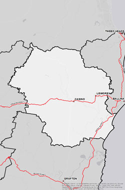
The Northern Rivers BFMC area spans 795,520ha. The area covers the Richmond Valley, Lismore and Kyogle Local Government Areas (LGAs) and features 33 National Parks covering an area of 118,471ha and 30 State Forests covering area of 91,881ha.
The Northern Rivers BFMC area has approximately 68% bushland and 29% grassland. A bush or grass fire can happen at any time of the year, but the risk is higher during the warmer months, when bush, grass or scrub is drier.
-
 At the last census there are 33,450 homes in the Northern Rivers area with an approximate population of 78,312.
 -
 The area has a high level of primary agricultural industries and associated food manufacturing, a moderate level of tourism, a low level of industry and a moderate level of local business and opportunities for employment.
 -
 The last major bush fires happened in the 2019/20 bush fire season with 170,855ha burned.
 -
 There are several valuable community assets across the area along with a number of culturally significant sites and environmentally important sites.
Current Bush Fire Risk Management Plan for Northern Rivers
The Northern Rivers Bush Fire Risk Management Plan was published on 25 February 2021.
This plan identifies the bush fire risks in Northern Rivers and sets out the types of work scheduled to deal with the risk of bush fires.
BFRMPs are updated within every five-year period, however, the treatments and works set out in the plans are subject to change on a yearly basis due to fire activity, weather and new risk factors. This plan may not have been updated with the latest treatment and works plans/information.
Northern Rivers BFMC is made up of a range of stakeholders from the area including emergency services, land management agencies, local government, local Aboriginal land services and local community groups. This ensures key community stakeholders have a say on bush fire management activities for the benefit of their communities.
The Northern Rivers BFMC is made up of the following representatives:
- NSW Rural Fire Service
- NSW Department of Planning and Environment (Crown Lands)
- Essential Energy
- NSW Farmers' Association
- Fire and Rescue NSW
- Richmond Valley Council
- Lismore City Council
- Kyogle Council
- Local Aboriginal Land Councils
- Nature Conservation Council of NSW
- NSW National Parks and Wildlife Service
- NSW Police Force
- Transport for NSW
- Australian Rail Track Corporation
- Department of Defence
- Forestry Corporation NSW
- Richmond River Cane Growers Association

For more information contact your local NSW RFS Fire Control Centre

